|
(UPDATED 6/26 AT 7:45 AM) The Storm Prediction Center has now put a very small area of Southern Wisconin under a Slight Risk for severe weather.
0 Comments
The very uncomfortable, tropical-like humidity we experienced about a week ago will return next week. Flooded streets were a common sight across Wisconsin last weekend as the same type of humidity caused a multi-day rain event across Wisconsin, but mostly across Northern Wisconsin. This multi-day rain and thunderstorm event caused major flooding. It even caused concern that dams were going to fail. Flash Flood Emergencies were issued and Wisconsin Governor Scott Walker even declared a State of Emergency for Northwestern Wisconsin.
After a weekend full of strong to severe thunderstorms, the upcoming weekend is going to look beautiful! It should be rain free across the state with partly cloudy skies! A perfect first weekend of summer!
Here's the forecast! A Flash Flood Watch is in effect for Lafayette, Green, Rock, Walworth and Kenosha counties until 7:00 AM Friday, June 22nd. Showers and thunderstorms are expected to impact the region today and tonight bringing 1-2" with potentially higher amounts. This rain will impact the same area that was hit by heavy rain earlier this week.
The National Weather Service offices across Wisconsin have been busy all day today with the storms moving through, but also in the temperature department. Many have issued Heat Advisories for the very warm temperatures and the humidity that will set it tomorrow.
All information in this article is from the National Weather Service Green Bay. See their article: https://www.weather.gov/grb/060707_tornadoes [June 7, 2007] - It was a dangerous day on June 7th of 2007. The Storm Prediction Center issued a HIGH RISK for severe weather, showing extreme concern about the upcoming storms that will eventually hit Wisconsin.
There is a line of storms that have developed in Iowa that will be impacting West-Central and South-Central Wisconsin, possibly bringing Flash Flooding to the area.
According to doppler radar, Mason City, IA has received 5"+ from this same system that will track over Wisconsin. The Weather Prediction Center (WPC) has voiced their concern regarding the threat for Flash Flooding by issuing a Mesoscale Precipitation Discussion (read it here).
From a blizzard that dropped 2 to 3 feet across Wisconsin just over a month ago, to now, record heat across the state, with highs even reaching into the 90s today and tomorrow. 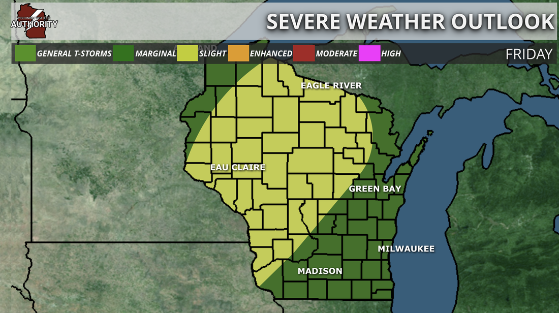 Storm Prediction Center's severe weather outlook for Friday Storm Prediction Center's severe weather outlook for Friday
UPDATED 5/25:
The Storm Prediction has now extended the Slight Risk area more northward, now including portions of the Fox Cities. Here's a breakdown of what's expected: |
Archives
June 2018
Categories |
 RSS Feed
